


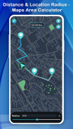
Distance & Location Radius - Maps Area Calculator

Description of Distance & Location Radius - Maps Area Calculator
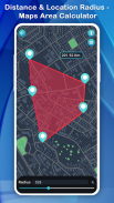
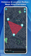
Distance & Location Radius - Maps Area Calculator allows you to measure distances on a map by two ways.
In thisDistance & Location Radius - Maps Area Calculator Application In first user can place pins on map and measure distance between consecutive pins then after user can measure continuous path among
Points by pen tool. To do this user must click on map to place the pen first then long pressing on pen will activate the continuous drawing.
With this Distance & Location Radius - Maps Area Calculator Application user can get information about their nearby area from Google map and also share their live location with others and save this
Location which is search by users.
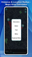
You can get information about distance of your surrounding area in different Measurement like Kilometers, Meters, Feet, Miles, Nautical miles...
It helps you greatly in measuring anywhere, while you are traveling someplace if you want to calculate the distance between two points and cities.
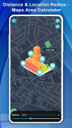
Distance & Location Radius - Maps Area Calculator app will extremely help you in the calculation of that property mapping measure distance.
Farmers who have farms and grow wheat, corn, assault, maize, sugar beet and need to do quite a long time field measuring occupation to check planted territory this is to best fit all needs.
You can make land conversion and measurement, GPS navigation accuracy, converter to the area and land distance measurement by using the app.
How to use?
- Go to Play store and download Distance & Location Radius - Maps Area Calculator app
- Open the app and Find out your position on map
- Locate area on the map which you want to explore
- Drop the pin by clicking on screen
- Get distance or find route from your place
- Result give you how far from the place and
- How much time taken to reach their place
- Travel new places and explore new route of your journey.


